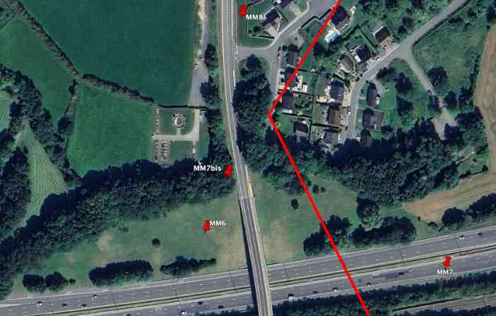
Fortifications belges de la deuxième guerre mondiale, position fortifiée de Liège, intervalle Manaihant-Margarins, abri MM 8. Détruit lors de la construction du pont qui enjambe l'autoroute A3/E42. L'abri MM 8 se trouvait à gauche et en bordure de la route de Battice vers Verviers, 314 m/alt, 140 m au nord de l'abri MM 7bis. Il devait interdire celle-ci. Probablement intervenue lors de la construction de l'autoroute Roi Baudouin A3/E42, sa destruction ne s'imposait pourtant pas vraiment, si ce n'est par l'aménagement de la route N 627, rue de Verviers, en avant du pont.
Belgische Festungen aus dem Zweiten Weltkrieg, verstärkte Stellung Lüttich, Intervall Manaihant-Margarins, Unterstand MM 8. Zerstört beim Bau der Brücke, die die Autobahn A3/E42 überspannt. Der Unterstand MM 8 befand sich links am Rand der Straße von Battice nach Verviers, 314 m/ü. M., 140 m nördlich des Unterstands MM 7bis. Er sollte diese sperren. Wahrscheinlich im Zuge des Baus der Autobahn Roi Baudouin A3/E42 erfolgt, war seine Zerstörung doch nicht wirklich zwingend, außer durch den Ausbau der Straße N 627, Rue de Verviers, vor der Brücke.
Belgische fortificaties uit de Tweede Wereldoorlog, versterkte stelling Luik, interval Manaihant-Margarins, schuilkelder MM 8. Vernietigd tijdens de bouw van de brug die de autosnelweg A3/E42 overspant. De schuilkelder MM 8 bevond zich links aan de rand van de weg van Battice naar Verviers, 314 m/TAW, 140 m ten noorden van de schuilkelder MM 7bis. Hij moest deze afsluiten. Waarschijnlijk gebeurd tijdens de bouw van de autosnelweg Roi Baudouin A3/E42, was zijn vernietiging toch niet echt noodzakelijk, tenzij door de aanleg van de weg N 627, Rue de Verviers, voor de brug.
Belgian fortifications from the Second World War, fortified position of Liège, interval Manaihant-Margarins, shelter MM 8. Destroyed during the construction of the bridge spanning the A3/E42 motorway. Shelter MM 8 was located on the left side at the edge of the road from Battice to Verviers, 314 m/asl, 140 m north of the shelter MM 7bis. It was to block this road. Probably carried out during the construction of the Roi Baudouin A3/E42 motorway, its destruction was not really imperative, except due to the development of road N 627, Rue de Verviers, in front of the bridge.
Belgické opevnění z druhé světové války, opevněná pozice Lutych, interval Manaihant-Margarins, bunkr MM 8. Zničen během výstavby mostu překlenujícího dálnici A3/E42. Bunkr MM 8 se nacházel vlevo při okraji silnice z Battice do Verviers, 314 m/n. m., 140 m severně od bunkru MM 7bis. Měl ji zablokovat. Pravděpodobně k ní došlo během výstavby dálnice Roi Baudouin A3/E42, jeho zničení však nebylo skutečně nezbytné, leda z důvodu úpravy silnice N 627, Rue de Verviers, před mostem.